|
|
|
|
11,95 $
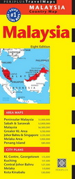
The Malaysia Travel Map from Periplus is designed as a convenient, easy-to-use tool for travelers.
This map, created using durable coated paper, is made to open and fold multiple times, whether ... » Lire la suite...
TUTTLE PUBLISHING
|
mars 2025
|
Sur commande :
2 à 4 semaines
|
|
|
|
|
|
114,00 $
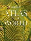
The only world atlas updated annually, Oxford's Atlas of the World is the most authoritative atlas on the market.
Full of crisp, clear cartography of urban areas and natural landscapes around th... » Lire la suite...
OXFORD UNIVERSITY PRESS
|
septembre 2024
|
Sur commande :
2 à 4 semaines
|
|
|
|
|
|
105,00 $
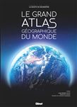
Atlas mondial physique et politique des différentes régions géographiques du monde, y compris les océans. Avec une série de photographies prises de l'espace, un répertoire synthétique des principal... » Lire la suite...
GLENAT
|
décembre 2024
|
En stock :
Expédié en 3 à 5 jours
|
|
|
|
|
|
22,95 $
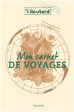
Le carnet de voyages du routard . - des cartes, des to-do, des check-lists pour organiser son séjour et partir l'esprit tranquille !
- des pages à remplir avec ...
» Lire la suite...
HACHETTE
|
novembre 2024
|
En stock :
Expédié en 48 heures.
|
|
|
|
|
|
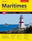
19,95 $
Comprend: Nouveau-Brunswick, Nouvelle-Écosse, île-du-Prince-Édouard
MAPART
|
janvier 2023
|
En réapprovisionnement :
Habituellement expédié en 4 à 10 jours.
|
|
|
|
|

|
59,95 $
Atlas mondial physique et politique des différentes régions géographiques du monde, y compris les océans. Avec une série de photographies prises depuis l'espace.
GLENAT
|
octobre 2024
|

|
49,95 $
En parallèle de son image mondiale de « Ville Lumière », Paris présente une face obscure et mystérieuse, grouillant d'activités occultes et de croyances extraordinaires.. Ce Paris fantastique, peup... » Lire la suite...
LE LOTUS ET L'ÉLÉPHANT
|
décembre 2024
|
En stock :
Expédié en 3 à 5 jours
|
|
|
|
|
|
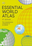
22,00 $
Revised and fully up-to-date!
A handy, user-friendly atlas at an affordable price, Essential World Atlas is perfect for home, school, and office use.
Featuring a series of thematic world maps... » Lire la suite...
DORLING KINDERSLEY
|
décembre 2024
|
Sur commande :
2 à 4 semaines
|
|
|
|
|

|
19,99 $
Named one of the best road trips in the world by The Times and DK, this is afull colour, informative map of the popular Pacific Coast Highway. With detailed mapping, key tourist information and a s... » Lire la suite...
COLLINS
|
septembre 2024
|
Sur commande :
2 à 4 semaines
|
|
|
|
|
|
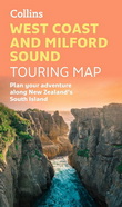
19,99 $
Featured as one of the best road trips in the world by Rough Guide and Booking.com
Full colour, informative touring map featuring the West Coast of New Zealand’s South Island. With detailed mapp... » Lire la suite...
COLLINS
|
septembre 2024
|
Sur commande :
2 à 4 semaines
|
|
|
|
|
|
|
1449 article(s) au panier.
Renaud-Bray vous offre
les frais de livraison *
|